


C29 Metals Limited (“C29” or the “Company”) is pleased to announce that it has received Category four (4) exploration approval enabling the immediate commencement of tenement wide, geophysical, field mapping and soil sampling programs at its newly granted southern and northern tenements.
HIGHLIGHTS
C29 has received Category four (4) exploration works approval for its newly granted southern & northern tenements.
Immediate commencement of airborne geophysical & ground engaging geological programs excluding drilling.
The Company anticipates that the drilling contractor will commence mobilisation to site for the initial diamond drilling program at the Ulytau tenement by the end of this week.
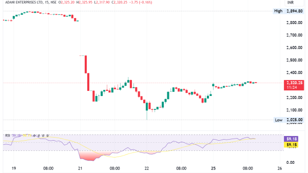
The Company’s geology team is already established on site with the impending initial diamond drilling program commencing shortly at its Ulytau tenement (#1860-EL) and will simultaneously commence airborne geophysics programs on Ulytau and the southern tenement (#2786-EL). Refer Figure 1 for Ulytau Uranium Project Tenement locations and geophysical survey flight lines.
The Category 4 approval has been granted in rapid time and once again demonstrates the efficiency of the Kazakhstan regulators and the respected relationship that C29 Metals has established at all levels of government and regulators.
The Company anticipates that the drilling contractor will commence mobilisation to site for the initial diamond drilling program at the Ulytau tenement by the end of this week.
Exploration activities on the Company’s northern tenement (#2826-EL) are scheduled for Q1 of CY2025.
C29 Metals Managing Director, Mr Shannon Green, commented:
“It is very exciting to have the Category four (4) exploration approval granted enabling our geology team to immediately commence both boots on ground and airborne field works. This once again demonstrates the positive operating environment in Kazakhstan and the support the company is enjoying”.
Airborne Geophysical survey
The airborne geophysical survey is a helicopter borne electromagnetic survey over EL1860 and EL2786. Refer Figure 1 for Ulytau Uranium Project Tenement locations and geophysical survey flight lines.
The survey will acquire electromagnetics, magnetics and radiometrics. Modern advancements in processing of electromagnetic surveys allow a much more sophisticated interpretation. To this end, Intrepid geophysics based in Melbourne, Victoria have been engaged to oversee survey design and processing. The processing will be completed using the proprietary “Moksha” 2.5D inversion technique detailed In Paterson, 2021 “2.5D Airborne Electromagnetic inversion: A review of the benefits of moving to a higher dimension”.
Click here for the full ASX Release